|
|
||
|
|
||
|
Atlas Grid |
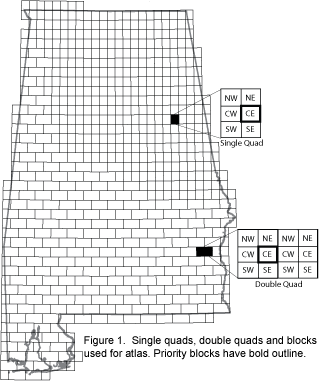
Atlas Grid The atlas project used different sampling methods in the upland and Coastal Plain regions of the state. In upland regions, the central east (CE) block from a single quad was surveyed (Fig. 1). If breeding evidence for a species was found in the CE block of a single quad, then the species was considered to breed within that quad (60 sq mi) (Fig. 1). In the Coastal Plain, the CE block of the more western quad of a "double quad" area was sampled (Fig.1). If breeding evidence for a species was found in the western CE block of a double quad, then the species was considered to breed within those two quads (120 sq mi). Sampling effort within these CE blocks or "Priority Blocks" was standardized, and therefore results from these blocks best reflect the breeding distribution of each species within the state.
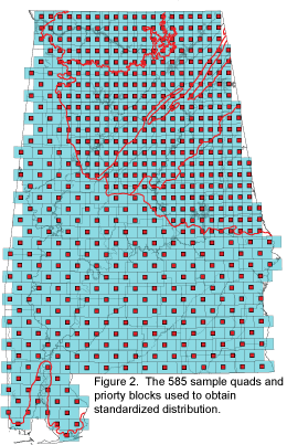
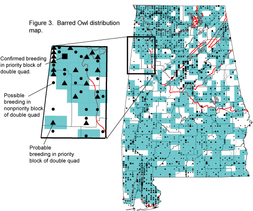
The standardized distribution of a species was determined by using 585 sample quads (blue) and their priority blocks (red) (Fig. 2). If evidence of breeding for a species was found in the priority block within a single or double quad, the quad was colored blue (or shaded) and the level of breeding evidence symbolized (Fig. 3). If the species was found in any of the other 5 blocks of a single quad or 11 blocks of double quad, then the quad was not colored, but the level of breeding evidence was symbolized (Fig. 3). It should be repeated, only priority blocks received the same level of effort, and focusing on just symbols can lead to an incorrect interpretation of the distribution of a species within the state.
HHHHHHHHHHHHHH
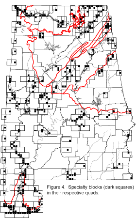
Although the primary focus of the sampling effort occurred within the designated CE blocks (Fig. 2), considerable surveying effort also was conducted in "specialty blocks" (Fig 4). These blocks were deemed special because they contained unique habitats, and/or species, or occured along the state border. Sampling these blocks greatly improved the thoroughness of the atlas project.
Atlas Regions
Region 1: Lauderdale,
Limestone, Colbert, Franklin, Lawrence, Morgan, Marion, Winston, and Cullman
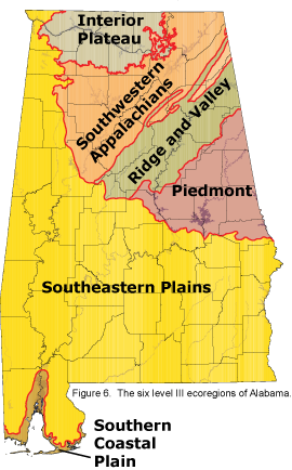
Breeding Codes The CONFIRMED designation was used for a species when there was unquestionable evidence of breeding as indicated by the following: CN -- Carrying nest material (nest not seen). NB -- Nest building, not wrens or woodpeckers (see N, below). DD -- Distraction display (life threatening). UN -- Used nest or eggshells (caution with this one). NE -- Nest with eggs. Cowbird egg or young also confirms host species. ON -- Occupied nest (contents not determined). IP – Incubating position. Don’t know if bird is incubating or brooding. NY -- Nest with young (seen or surmised). FS -- Adult carrying a fecal sac (white) from nest. One way to surmise NY. CF -- Carrying food (young not seen). FL -- Short-tailed fledglings, chicks, and young dependent on adults or adults’ territory. BG -- Begging young heard but not seen (e.g., owls, crows). The PROBABLE designation was used for a species when there was very suggestive evidence of breeding but no actual evidence of nesting was found. This designation was used when one of the following was noted: 7 -- Seven or more widely distributed singing males observed in a single visit within safe dates. This code served to direct attention away from common species by providing a way to quickly upgrade them to Probable. It was also the only numerical code that was used and can therefore help indicate how common a species was in a block (i.e., seven or more or less than seven). P -- Pair detected within suitable habitat and safe dates. You can distinguish a pair by differences in plumage or by behavior (two doves hanging together). T -- Territorial behavior presumed by presence of singing male at same stop 5 or more days apart. C -- Copulation or courtship, including mate feeding. Some species copulate away from their breeding territories, hence the caution of not using this as Confirmed breeding. A -- Agitated behavior or anxiety calls by adults. This includes behavior just short of distraction displays. The loud cries and scolding given by birds in the presence of a snake, a marauding crow, or a female cowbird suggest that it has a nearby nest. This code was not used for responses to taped recorded songs and spishing. N -- Nest building by wrens or woodpeckers. Male wrens can start nests before pairing. Woodpeckers excavate roost cavities. Also for observations falling just short of finding the nest without climbing but where a nest is indicated. The POSSIBLE designation was used for a species when there was suggestive evidence of breeding as indicated by the following: X -- Species found in suitable habitat within safe dates. H -- Singing male or territorial call heard in suitable habitat within safe dates. The OBSERVED designation was used for a species when there was no evidence of breeding other than the species being seen within the safe dates. This designation was only recorded consistently for species that nest in colonies (e.g., Great Blue Heron and Double-created Cormorant) and/or often fly and forage considerable distances from their nesting areas (e.g., Swallow-tailed Kite). Seasonal Coverage, Safe Dates and Study Period Fieldwork was conducted from mid-winter, when Great Horned Owls are nesting, into September, when doves and American Goldfinches may still be raising young. Most field work took place in May, June and July, when most species are breeding (geese, nuthatches, and kingfishers are mostly done by June 1, and woodcock even earlier). "Safe dates" were established for most species to reduce that likelihood that migrants would be counted as breeding birds. The first safe date listed for a species was based on when the last migrants are known to pass through the state and local residents first establish territories or begin courtship. The last safe date was based on when returning migrants are known to show up and/or when dispersing local birds leave their territories. Safe dates were dictated by bird movements, not by nesting itself. Evidence of breeding can be noted for a species before or after its safe dates, so effective fieldwork often started early and continued through most of July for most species. This study was a continuation of an atlas project run in the Tennessee Valley in northern Alabama during 1995-97 under the guidance of the Department of Conservation and Natural Resources (DCNR). Data from that atlas work (3,717 records) were incorporated into this project (265,747 records). Only data from CE blocks were recorded in the 1995-97 and these blocks were revisited between 2002-2006. Preliminary atlas work began in 2000 and 2001, and 38,881 records were collected. The majority (84%) of the breeding bird atlas records, however, were collected between 2002 - 2006. EcoregionsTo better understand the distribution of bird species within the state, distribution data for the level III ecoregions are presented with the species maps. Figure 6 illustrates the level III ecoregions found in Alabama, and below are general descriptions of the regions (EPA 2002).
Interior Plateau -
The Interior Plateau is a diverse ecoregion extending from southern
Indiana and Ohio to northern Alabama. Rock types are distinctly
different from the coastal plain sediments and alluvial deposits to
the west, and elevations are lower than the Appalachian ecoregions
to the east. Mississippian to Ordovician-age limestone, chert,
sandstone, siltstone and shale compose the landforms of open hills,
irregular plains, and tablelands. The natural vegetation is
primarily oak-hickory forest, with some areas of bluestem prairie
and cedar glades. Southwestern Appalachians - Stretching from Kentucky to Alabama, these open low mountains contain a mosaic of forest and woodland with some cropland and pasture. The eastern boundary of the ecoregion, along the more abrupt escarpment where it meets the Ridge and Valley, is relatively smooth and only slightly notched by small. eastward flowing streams. The western boundary, next to the Interior Plateau's Eastern Highland Rim, is more crenulated, with a rougher escarpment that is more deeply incised. The mixed mesophytic forest is restricted mostly to the deeper ravines and escarpment slopes, and the upland forests are dominated by mixed oaks with shortleaf pine. Coal mining occurs in several parts of the region. Ridge and Valley - This northeast-southwest trending, relatively low-lying ecoregion is sandwiched between generally higher, more rugged mountainous regions with greater forest cover. As a result of extreme folding and faulting events, the region’s roughly parallel ridges and valleys have a variety of widths, heights, and geologic materials, including limestone, dolomite, shale, siltstone, sandstone, chert, mudstone, and marble. Springs and caves are relatively numerous. Present-day forests cover about 50% of the region. The ecoregion has a diversity of aquatic habitats.
Piedmont -
Considered the nonmountainous portion of the old Appalachians Highland
by physiographers, the northeast-southwest trending Piedmont ecoregion
comprises a transitional area between the mostly mountainous ecoregions
of the Appalachians to the northwest and the relatively flat coastal
plain to the southeast. It is a complex mosaic of Precambrian and
Paleozoic metamorphic and igneous rocks, with moderately dissected
irregular plains and some hills. The soils tend to be finer-textured
than in coastal plain regions. Once largely cultivated, much of this
region has reverted to successional pine and hardwood woodlands, with an
increasing conversion to an urban and suburban land cover.
Southern Coastal
Plain - This ecoregion consists of mostly flat plains, but it is a
heterogeneous region containing barrier islands, coastal lagoons,
marshes, and swampy lowlands along the Gulf and Atlantic coasts. This
ecoregion is lower in elevation with less relief and wetter soils than
the Southeastern Plains. Once covered by a variety of forest communities
that included trees of longleaf pine, slash pine, pond pine, beech, sweetgum, southern magnolia, white oak, and laurel oak, land cover in
the region is now mostly slash and loblolly pine with oak-gum-cypress
forest in some low lying areas, pasture for
beef cattle, and urban. |
|
| © Alabama Breeding Bird Atlas - All Rights Reserved | ||

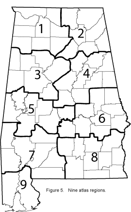 ge of the priority blocks, the state was divided into 9 atlas regions
(Fig. 5).
The boundaries of these regions were formed by roughly
following the degree parallels to divide the state into 5 slices, and
the 86
ge of the priority blocks, the state was divided into 9 atlas regions
(Fig. 5).
The boundaries of these regions were formed by roughly
following the degree parallels to divide the state into 5 slices, and
the 86